As appeared in the September 25, 2023 edition of The Altoona Mirror:
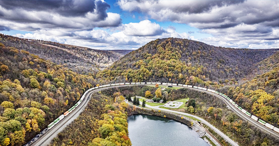
The Altoona Water Authority is working with the Pennsylvania Environmental Council on a project that could result in a 20-mile network of mountain bike trails on 3,500 acres above the Horseshoe Curve.
Such a network could help the local economy, as outdoor recreation attracts visitors who support businesses — with some visitors impressed enough to move here for work and to start their own companies, according to Steve McKnight, CEO of the Altoona Blair County Development Corp.
A consultant for PEC expects to create a master plan for the network, which would supplement an eight-mile mountain bike trail network created recently by a local club, a network that is accessible near the top of Glen White Run Road, according to Helena Kotala, program/mapping manager for trails and outdoor recreation for the council.
“We’re at the beginning stages,” authority Land Manager Katie Semelsberger told her board Thursday. “Nothing so far but meetings and site visits.”
Fieldwork on the master plan should begin early next year, and the plan should be complete by the end of that summer, Kotala said.
The network would be located between the edges of the existing club network and Kittanning Run, which flows in the hollow that intersects with Veterans Memorial Highway on the other side of the Curve visitor center from Glen White Road, Kotala said.
Applied Trails Research will be designing sustainable trails that exploit the existing topography, she said, adding the trails would be weather resistant, “so that when it’s rainy and wet, it won’t turn into a muddy mess.”
They’ll also be designed to require minimal maintenance, she said, and be “flowy,” to “meander along and traverse along the sides of slopes, with gradual ups and downs.”
Kotala declined to say how much the master plan will cost or how PEC will pay for it.
Following completion of the plan, there will be an evaluation about construction.
The network will probably be built in phases, a few miles at a time, and could be done by a company under contract or the local club, by machine or by hand, she said.
Machine-built trails tend to be wider and smoother, while hand-built trails tend to be more “raw and rocky,” she said.
The proposed trail above the Curve could give Blair County the equivalent of Huntingdon County’s Allegrippis Trails and Centre County’s trails in Rothrock State Forest, McKnight said.
“It could be a real game changer for us,” he added.
Mountain bike trails often bring families who stay multiple days, which means they spend on hotels, restaurants and other local businesses, McKnight said.
Trail networks also help develop appreciation and respect for the “natural environment,” resulting in a protective attitude for users, he said. “It helps you not to want to gobble up these natural wooded areas.”
It’s a major advantage for the project that the entire property is owned by the authority, which eliminates the common challenge of obtaining easements from multiple private property owners, McKnight said. “That’s what’s unique about the property.”
The network will be especially attractive for being located in the vicinity of historical sites, including the Curve itself, he said, stating “the vistas are unbelievable.”
Making the property available for recreation helps the authority fulfill a requirement imposed by its having accepted a $900,000 Department of Conservation and Natural Resources grant to pay for half of the purchase price of the watershed property, which was formerly owned by Cooney Bros. Coal Co., said authority General Manager Mark Perry.
The project will not place a financial burden on the authority, Semelsberger said, and at some point, there are likely to be community workshops to train volunteers for trail maintenance.
“It’s great for us,” and gives people the opportunity to use watershed land “for the right reasons,” said authority board Chairman Bill Neugebauer.
Mirror Staff Writer William Kibler is at 814-949-7038.


